Koetter Red Willow County Auction-S
McCook, NE 69001
Red Willow County, Nebraska
Land Description
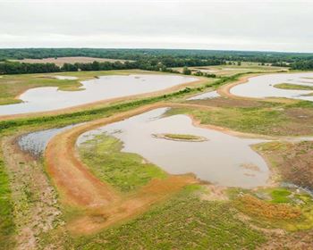
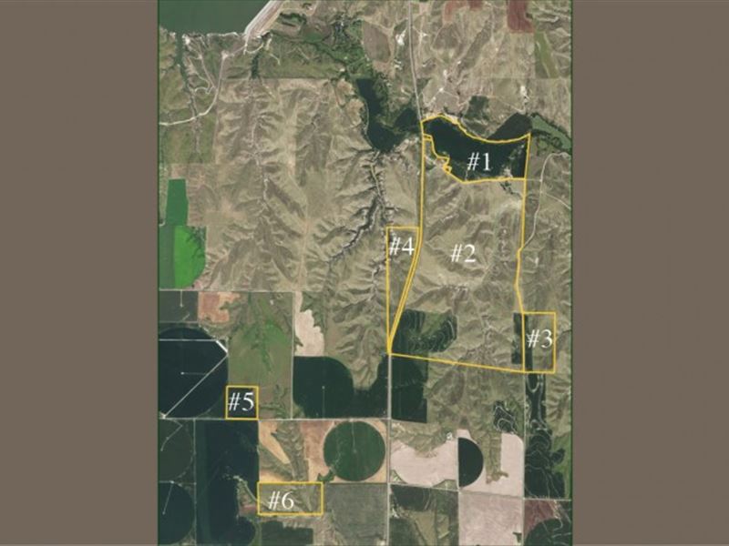
Absolute Auction September 12, 2017 - 1 00 P.M. Auction to be held at the Red Willow Fairgrounds Community Hall - West 5th Street - McCook, Nebraska Location Parcels are located approximately 7 miles north of McCook, Nebraska Details The Red Willow County Assessor's office has a total of 1,278.97 taxable acres on all six parcels combined. The total acres including the 2 feedlots, roads and waste and old building sites total 1,278.97 measured acres. This estimate includes 35 acres of rangeland in Parcel 1. This can only be isolated more closely with a survey should Parcel 1 and Parcel 2 sell separately. According to the Red Willow County Assessor's Office there is a total of 984.79 acres of grass, 148.87 acres of drycrop, 15.46 acres of roads, 122.40 irrigated acres and 7.45 site acres on all 6 parcels combined. Legal Description See Exhibit A Taxes Estimated Parcel 1 Parcel 1 lies north of Road 725 and east of Highway 83. This parcel has 2 pivots that irrigate a total of 82.75 according to the Red Willow County Fsa. There is a Valley Pivot that lies to the west side of the field that is serviced by a well that is north of Red Willow Creek and off of the boundary line of the property. This well has an easement via the will of William D. Koetter. The east pivot is a small Reinke pivot that is owned by one of the owners, David Koetter. It will be up to the buyer of the property to decide and negotiate with the owner as to the purchase of the pivot. The east pivot is serviced by a well that is on the south side of the field. Said well also had underground pipe to irrigate 17.87 FSA measured acres on the east side of the property of Parcel 1. There is irrigation pipe that goes with the property there is not any livestock equipment that currently is present on the property included in the sale. This personal property belongs to one of the current owners. The East feedlot is included with Parcel 1. There is a submersible well on this property. By adding the FSA acres along with estimated measurements there would be approximately 140 acres in Parcel 1. Parcel 2 Parcel 2 consists of hardland pasture with some drycrop. It is bordered by US Highway 83 on the west side of the property and partially bordered by County Road 385 on the east. Parcel 2 is watered by 1 windmill located approximately in the center of the rangeland. Parcel 2 also has 1 submersible well north of County Road 725. The tenant previously had run a hose from the submersible well in Parcel 2 across County Road 726 to fill tanks to water cattle. There is also a stock dam located on the northeast corner of the property. Also included in Parcel 2 is some rangeland north and west of 2 Husker Harvesters that are located north of Highway 725 and are included in Parcel 2. The west feedlot is included in Parcel 2. According to the Red Willow County FSA there is a total of 697 acres south of Road 725. We have estimated that there would be approximately 35 acres of pasture north of Road 725. This would make a total of 732 range acres. FSA has measured 98.72 drycrop acres in Parcel 2. This would make a total of 830.72 total estimated acres. Parcel 3 Parcel 3 consists of 53.44 FSA measured range acres and 15.01 drycrop acres for a total of 68.45 acres. Again, this is acres measured by the Red Willow County Fsa. There is an alleyway on the north side of Parcel 3 that allows cattle to go to the windmill located in Parcel 2. Previously there was an arrangement with a relative to the south to use a water source for the south end of Parcel 3. This is not an easement and arrangements would have to be made by the buyer should Parcel 3 be sold separately with a neighbor to water the livestock pasture in Parcel 3. This parcel is adjacent to County Road 385, providing great access. Parcel 4 Parcel 4 is 78.03 FSA measured range acres located west of US Highway 83. It is also west of Parcel 2 across Highway 83. There is not water source on this range/pastures. Previously there was an arrangement with a relative of the family to obtain water from a windmill located on the west side of said Parcel 5. However, there is no arrangement currently in place. A potential buyer would have to provide a water source or negotiate with the owner west of the property to use his existing windmill for a livestock water source. Parcel 5 Parcel 5 consists of 34.74 FSA measured drycrop acres and 4.95 off season grazing pasture. This totals 39.69 acres. It is accessed by County Road 723. Parcel 6 Parcel 6 is located mile south of County Road 722. An easement exists from county road 722. There is no water source in Parcel 6. It consists of 80.82 FSA measured range acres. The new buyer would have access from said road. The new buyer would also have to provide their own water source for grazing. There would be a total of 80.82 Red Willow County FSA measured acres.