Road Access, NC Mountain Land
Poplar Trail : Creston, NC 28615
Ashe County, North Carolina
Land Description
Owner Financing:
- $299 down (plus the $499 doc fee)
- $299 down $298/Mo for 72 months (plus prorated taxes and note maintenance fee)
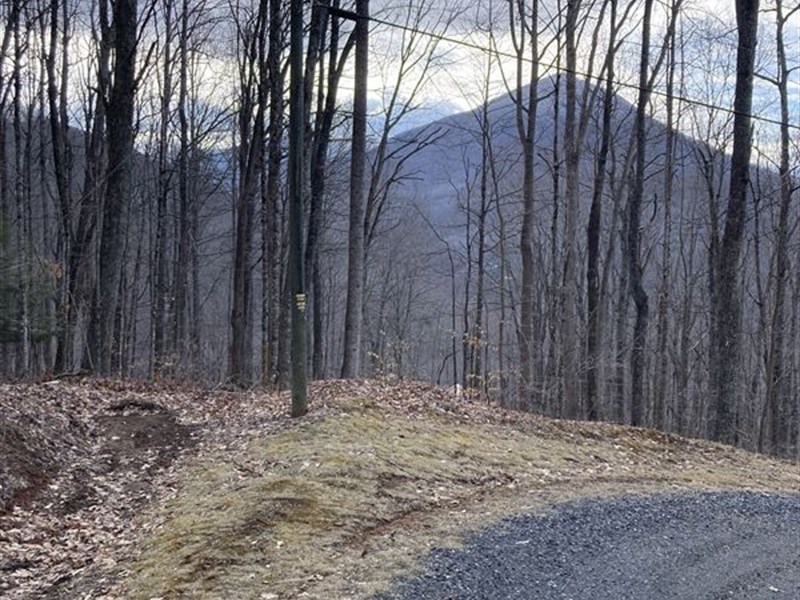
Nestled in the serene landscapes of Ashe County, NC, this 0.95-Acre vacant land offers a rare blend of convenience and natural beauty. Accessible via an easy and well-maintained gravel road, even a Honda Accord can navigate it effortlessly, ensuring smooth arrivals and departures for your adventures. Adding to its appeal are power lines conveniently situated in front of the property, simplifying utility setups for your dream home.
Adjacent to this idyllic land is a charming house, enhancing the neighborhood's charm and fostering a sense of community. Picture-perfect views of the surrounding hills and greenery create a picturesque backdrop, ideal for relaxation and rejuvenation. The level terrain presents ample space for building your dream retreat, complete with trees and rocks that add character and charm to the landscape.
Located in close proximity to the Three Top Mountain State Game Lands, outdoor enthusiasts will find endless opportunities for exploration and adventure right at their doorstep. Whether you seek a peaceful getaway, or a permanent residence immersed in nature's beauty, this property has all the elements for turning your aspirations into reality. Don't miss out on this chance to own a piece of Ashe County's natural splendor. Contact us today to schedule a viewing and experience the allure of this remarkable land firsthand.
State: Nc
County: Ashe
Zip: 28615
Size: 0.95 acres
Legal Description: Lot 48 of Three TOP Mountain, Continuation of Ridgewood Section, Ashe County, North Carolina, a Subdivision as recorded in the office of the Register of Deeds of Ashe County, North Carolina, in Book 4, Page 22, and subsequently replatted and recorded in Book 4, Page 355 a to which recorded plat reference is hereby made for a full and complete description.
Lat/Long Coordinates:
Nw: 36.421017, -81.611699
Ne: 36.420812, -81.611424
Sw: 36.420149, -81.611645
Se: 36.420120, -81.611331
Elevation: 3359 feet
Annual Taxes: Approx. $29 per year
Zoning: Residential
Flood Zone: No
HOA/POA: No
Improvements: No improvements done.
Access: Gravel Road
Water: Will need to install a Well
Sewer: Will need to install a Septic System
Utilities: Electric
Owner Financing:
- $299 down (plus the $499 doc fee)
- $299 down $298/Mo for 72 months (plus prorated taxes and note maintenance fee)
Land Maps & Attachments
Directions to Land
From Charlotte, North Carolina, USA to Creston, North Carolina 28615, USA
-Get on I-77 N/US-21 N from W 4th St and W Trade St
6 min (1.4 mi)
-Head southwest on S Tryon St toward W 4th St
407 ft
-Turn right onto W 4th St
0.3 mi
-Turn right onto S Graham St
453 ft
-Turn left at the 1st cross street onto W Trade St
0.6 mi
-Turn right to merge onto I-77 N/US-21 N
0.3 mi
-Get on US-221 N in Triplett from US-421 N
1 hr 39 min (106 mi)
-Merge onto I-77 N/US-21 N
0.9 mi
-Keep right to continue on I-77 N
10.3 mi
-Keep left at the fork to continue toward I-77 Express Ln
Toll road
354 ft
-Continue onto I-77 Express Ln
Toll road
2.2 mi
-Use the middle lane to merge onto I-77 N
0.4 mi
-Keep left at the fork to continue on I-77 Express Ln
Toll road
4.2 mi
-Merge onto I-77 N
0.5 mi
-Slight left onto I-77 Express Ln
Toll road
3.4 mi
-Merge onto I-77 N
41.2 mi
-Take exit 73B to merge onto US-421 N toward Wilkesboro
Pass by Hardee's (on the left in 22.9 mi)
42.7 mi
-Turn right onto the ramp to US-221 N
0.4 mi
-Take Cranberry Springs Rd, Todd Railroad Grade Rd and 3 Top Rd to Poplar Trail in Creston
37 min (20.9 mi)
-Continue onto US-221 N
1.6 mi
-Turn left onto Cranberry Springs Rd
2.9 mi
-Turn right to stay on Cranberry Springs Rd
0.6 mi
-Cranberry Springs Rd turns left and becomes Todd Railroad Grade Rd
3.8 mi
-Turn left to stay on Todd Railroad Grade Rd
0.3 mi
-Continue onto 3 Top Rd
10.0 mi
-Turn right onto Eller Rd
171 ft
-Continue onto Hidden Valley Rd
0.8 mi
-Continue onto Oak Trail
0.3 mi
-Turn right to stay on Oak Trail
449 ft
-Continue straight onto Poplar Trail
Destination will be on the right
0.5 mi
More Land Details
Land Price History
More Land from Chris Palsgrove
 1.6 AC : $26K
 2.5 AC : $7.2K
 3.2 AC : $45.8K
 3.4 AC : $39.4K
 3.1 AC : $38.8K
 1.4 AC : $24K
 2.2 AC : $37.9K
 2.7 AC : $31.8K
 1.2 AC : $16K
 5.1 AC : $9K
 4.6 AC : $59.8K
 3.4 AC : $42.8K


