Affordable Green Acres Near A Lake
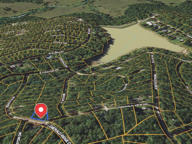
Emerald Ridge Dr : Sullivan, MO 63080
Washington County, Missouri
Land Description
This 0.35-Acre lot in Washington County, Missouri is the perfect canvas for your next big adventure. Located on Emerald Ridge Drive, this property offers central access to nearby highways, making it easy to stay connected while enjoying the serenity of nature.
Why This Property Stands Out:
Affordable & Flexible Financing: Own it for just $181.53/Month with easy owner financing. Start investing with only $200 down.
Zoning in Place: Build with confidence - residential zoning is already set, so your plans can take off stress-free.
No HOA Fees: Say goodbye to extra costs - no HOA means more freedom and flexibility for your land.
Close to Nature: Enjoy nearby hot spots like Bluff View Farm Rocks and Washington State Park, perfect for outdoor adventures.
Convenient Location: Just a short drive to Bonne Terre, where you can stock up on supplies and take advantage of local amenities.
Whether you're an eco-entrepreneur or looking to create a nature retreat, this lot has everything you need to make your dreams a reality.
Property Details:
Address: Emerald Ridge Dr. Sullivan, MO 63080
Size: 0.35 acres
Access: Emerald Ridge Dr
Taxes: Low annual taxes, keeping ownership affordable.
Pricing & Terms:
Cash Price: $9,999 (+ $249 doc fee)
Owner Financing: $200 down + $249 doc fee, then just $181.53/Month for 72 months.
This is your opportunity to own a piece of Missouri's rich landscape - perfect for building, farming, or simply escaping the everyday grind. Contact us now to make this land yours before it's gone.
Land Maps
Directions to Land
To navigate from St. Louis, MO to the coordinates 38.106033, -91.075075, here are the step-by-step driving directions:
Start in St. Louis, MO:
Get on I-44 W from Market Street or another central road.
Continue on I-44 W:
Stay on I-44 W for approximately 56 miles, heading southwest out of St. Louis.
Take exit 203 toward MO-100 E/Hwy 100:
Exit I-44 at Exit 203 for MO-100 toward Washington and New Haven.
Turn left onto MO-100 E:
Follow MO-100 E for approximately 1 mile.
Turn left onto Old Cove Rd:
After turning onto Old Cove Rd, proceed for about 0.5 miles until you reach your destination near the coordinates 38.106033, -91.075075.
This route is about 60 miles and should take roughly 1 hour depending on traffic and weather conditions. Make sure to use a GPS for precise tracking, especially as you approach rural areas near your destination.
More Land Details
More Land from Derek White
 2.3 AC : $10K
 20 AC : $25K
 10 AC : $12.8K
 20 AC : $16K
 22 AC : $24.8K
 10 AC : $12.5K
 20 AC : $24.8K
 5 AC : $20K
 2.3 AC : $8K
 0.3 AC : $12K
 2.1 AC : $8K
 10 AC : $12.8K
