Live Life Here for $168.94 Down
N Yucca Cir : Tombstone, AZ 85638
Cochise County, Arizona
Land Description
$168.94 Down, $168.94/Mo for 24 Months, 0% Int.
No Credit Checks. All Major Credit Cards Are Accepted.
Call or Text Us Now To Reserve.
30-Day Money Back Guaranteed.
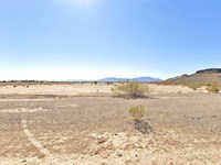
Discover the charm of this exceptional 0.26-Acre land in Tombstone, AZ, which provides a unique opportunity to own a piece of the Wild West's history. You'll be delighted to find Tombstone's charming downtown, complete with historic saloons, museums, and sites, just a short drive away. This area is a haven for outdoor enthusiasts, offering activities like hiking, horseback riding, off-roading, and bird watching in the nearby Coronado National Forest and San Pedro Riparian National Conservation Area.
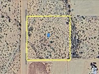
Property Location: Tombstone, AZ 85638
Lot Size: 0.26 Acre
Zoning: Residential and Recreational Use
Apn: 109-33-007
Electricity: Off-Grid, Would need Solar or other types of Alternative Energy
Primary Road: Dirt Road Access
Water: Would be from Alternative Sources
Time Is Ticking, Reserve It Now For Only $168.94. Invest In This Prime Property While it's Hot on the Market. Get Easy 24 Months Financing at 0% Interest, No Credit Checks, All Major Credit Cards Are Accepted.
Cheap and Affordable Vacant Land For Sale in Tombstone
Flexible Financing Options are Available
Owner Financed Rural Land in Arizona
Undeveloped Property For Sale With Direct Road Access
For Residential and Recreational Development in Cochise County
A Mobile Homesite Zone
Buildable Land Perfect Off-Grid Living
Desert Land With Mountain Views
Finance Land Near Entertainment Hubs
Perfect for Hiking and Hunting, Being Close To Recreational Centers
Quiet and Friendly Neighborhood
Located Near Schools, Parks, Shops, and Restaurants
Not in Flood Zone and Wetlands
Property Within Secured Subdivision
Land Maps & Attachments
Directions to Land
Center of Lot GPS Coordinates: 31.728617, -110.059669
GPS Coordinates for Corners of the Property:
Nw: 31.728557, -110.059917
Ne: 31.728822, -110.059621
Se: 31.728661, -110.059423
Sw: 31.728398, -110.059715
More Land Details
Land Price History
More Land from Patrick Elder
 10 AC : $19K
- 7.5 AC : $40K
- 19.1 AC : $699K
- 5 AC : $8K
- 2.5 AC : $11K
- 0.4 AC : $8K
- 2.5 AC : $7K
- 8.9 AC : $16K
- 1 AC : $20K
- 20.3 AC : $26K
- 2.5 AC : $14.5K
- 6 AC : $25K