Homesteader's Dream in Chiloquin
Chiloquin, OR 97624
Klamath County, Oregon
Land Description
Owner Financing:
- $100 down (plus the $250 doc fee)
- $100 down $275/Mo. for 72 months (plus prorated taxes and a $12/Mo note maintenance fee)
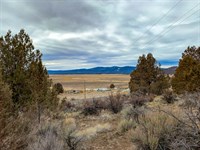
Are you feeling stuck in a never-ending cycle of work, bills, and stress? Do you find yourself daydreaming about a life where you call the shots, breathe fresh air, and live off the land? You're not alone. Millions of Americans are realizing that the "American Dream" they were sold isn't all it's cracked up to be.
Living in the city can be suffocating. The constant noise, pollution, and lack of space can take a toll on your mental and physical health. You dream of a simpler life, but the thought of leaving everything behind seems daunting and expensive.
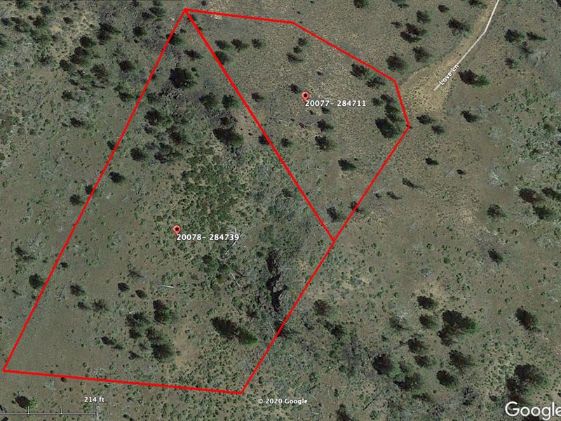
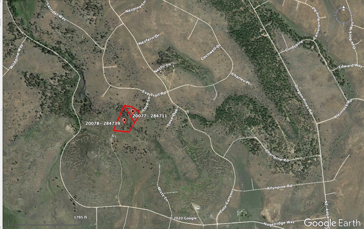
This oversized lot in the Oregon Pines subdivision is perfect for your homesteading dreams. With 4.2 acres to play with, you'll have plenty of room for a garden, some chickens, maybe even a cow or two. And if you're thinking big, there are two adjoining lots available, bringing the total to a whopping 7.38 acres.
Don't let another day go by feeling trapped in the city. Your new life of freedom, fresh air, and endless possibilities is waiting for you in Chiloquin. Make the move today and start living the life you've always dreamed of.
Subdivision: Oregon Pines
STREET Address: N/A, near Chiloquin, OR 97624
State: Or
COUNTY: Klamath County, Or
Zip: 97624
Size: 4.2 acres
LOT Dimensions: 476 feet (NE Leg) x 267 feet (SE Leg) x 387 feet (Southern Leg) x 663 Feet (Western Leg)
Apn: 284739
Legal Description: Those portions of Block 5 of Oregon Pines as recorded in Klamath County, Oregon. A portion of Lot 66, more particularly described as follows:Beginning at the Southeast corner of Lot 73 of said Block 5; thence North 59° 58' 54” East, along the southerly line of Lot 72, 259.86 feet to the Southwest corner of Lot 70; thence South 80° 40' 15” East, along the South line of Lots 70 and 69, 341.49 feet to the Southwest corner of Lot 67; thence South 55° 08' 57” East, along the southerly line of Lot 67, 258.37 feet to the westerly right of way line of Love Lane; thence Southerly along the southerly right of way line, along a curve concave to the Northeast, having a radius of 50.00 feet (the chord bears South 10° 08' 57” East, 70.71 feet) 78.54 feet to the Northwest corner of Lot 65; thence South 34° 51' 03” West, along the westerly line of Lot 65, 230.00 feet to the Southwest corner of Lot 65; thence South 31° 05' 16” West 265.32 feet to the Northwest corner of Lot 19; thence North 83° 11' 12” West, along the North line of Lot 19, 387.74 feet to the Northwest corner of Lot 19; thence North 10° 45' 47” West, 492.65 feet to the Southeast corner of Lot 73 and the point of beginning.Excepting an area beginning at the Southeast corner of Lot 73; thence North 59° 58' 54” East, along the southerly line of Lot 72, 259.86 feet to the Southwest corner of Lot 70, thence South 80° 40' 15” East, along the South line of Lot 70 to that point where the Northwest corner of Lot 66 meets the southerly line of Lot 70; thence South and West in a diagonal line to the Northwest corner of Lot 19; thence North 10° 45' 47” West, to the Southeast corner of Lot 73 and the point of beginning.NOTE: This Legal Description WAS Created Prior TO January 01, 2008. There hasn't been a deed recorded with the legal descriptions separated, a surveyor would need to supply the legal descriptions for this property.
Google Maps Link:
Lat/Long Coordinates:
Nw: 42.537833, -121.399306
Ne: 42.536703, -121.398394
Sw: 42.536189, -121.400334
Se: 42.536101, -121.398904
Elevation: 4,828 feet
ANNUAL Taxes: Approx. $108 per year
ZONING: (R-2) Rural Residential - Site built, mobile homes & manufactured homes are okay. The building code that Klamath County uses allows houses as small as 300 sq. ft. RV's are allowed for camping but not as a permanent residence.Camping is allowed for up to 21 days every 6 month period. Permits only required if staying for more than one week at a time. Tiny homes on trailer frames are registered by DMV as an RV so fall under the camping regulations.No time limit to Klamath County, OR Planning and Zoning Department at Phone: Option 4, for more info.
FLOOD Zone: Unsure
HOA/POA: No
IMPROVEMENTS: None
ACCESS: There is currently no road leading directly to this lot but an easement is on file with the county allowing access over parcels 283883 & 284711. 20 foot easement on the eastern edge of 284711 & a 20' easement on the western edge of 283883.
Water: Would be a well, water haul and holding tank or other similar option
SEWER: Would be by Septic
UTILITIES: Power by solar, wind or generator, Phone by cellular, satellite Tv/Internet/Phone
Land Maps & Attachments
More Land Details
More Land from Landopia, LLC
 0.5 AC : $19.3K
- 1.5 AC : $20.1K
- 5 AC : $15.1K
- 17.4 AC : $90K
- 10 AC : $15.4K
- 2.1 AC : $16.5K
- 20 AC : $25.7K
- 0.7 AC : $8.8K
- 0.3 AC : $22K
- 5 AC : $14.2K
- 1.5 AC : $18.5K
- 1.5 AC : $18.2K


